By Melissa Ward Jones, Institute of Northern Engineering, University of Alaska Fairbanks
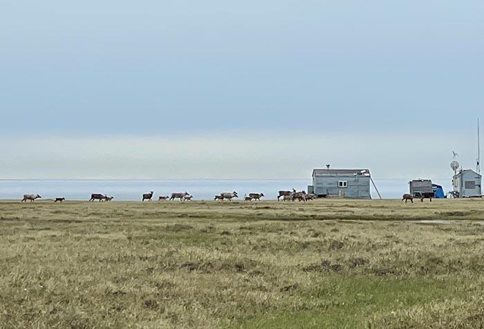
Lillian Jones, aged four, hops across an ice wedge trough near the Teshekpuk Lake Observatory (TLO) on Alaska's northern Coastal Plain. She is proud to have successfully jumped a depression measuring a few tens of centimeters across as we hiked 1.5 kilometers from the cabin (Figure 1) to one of our research sites. Ice wedge polygons are prevalent in terrestrial permafrost systems in the Arctic. On the Alaskan Coastal Plain, it is estimated that ice wedge polygons cover about 60% of the ground surface (Lara et al. 2018). Winter thermal contraction cracking and subsequent spring meltwater infiltration produces wedge ice that accumulates in significant amounts after repeating this cycle hundreds to thousands of times creating the polygonal patterns so evident from the air and space.

Lillian is my perpetual field assistant and has done Arctic fieldwork with me since she was two months old (Ward Jones and Bendixen 2022). We are at the TLO, along with TLO Director, science collaborator, husband and father, Benjamin Jones (Figure 2), to study ice wedge micro-topography and its impact on environmental parameters such as hydrology (Liljedalh et al. 2016), snow distribution (Gouttevin et al. 2018), vegetation (Jorgenson et al. 2015), carbon fluxes (Wainwright et al. 2015) and ground temperature (Ward Jones et al. 2020). This fieldwork is part of my NASA-funded project in the New (Early Career) Investigator Program (NIP; Award #80NSSC21K1820). In addition to collecting data at TLO we are also working in Utqiaġvik and Fairbanks.

Ice wedges create characteristic micro-topographic relief. This micro-topography is created during phases of wedge-ice accumulation that displaces soil to create elevated rims at the margins of ice wedge troughs and polygon centers (Figure 3). During periods of permafrost degradation, the tops of wedge ice melt, causing the ground surface to lower in the trough, creating a high-centered polygon system, where polygon centers are higher than the adjacent ice-wedge trough (Figure 3).

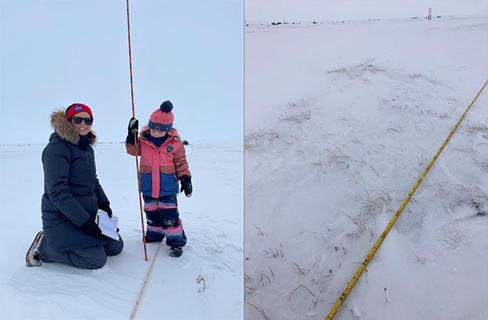
While topography varying by 0.5 to 1 m may not seem like it should have a big impact, preliminary analysis of ground temperatures at 0.15 m depth measured in a high-centered polygon system in Utqiaġvik, Alaska showed timing of freeze-up at two sites differed by 54 days. One site was a trough and the other a polygon center. Winter temperature minimums at these two sites varied by almost 5°C. This variability in ground temperature results from differences in environmental parameters like soil moisture and snow depth. Spring fieldwork in May measuring snow depths shows snow distribution on the landscape is reflective of micro-topography—polygon centers had a thin dusting of snow and troughs were filled (Figure 4), the amount of wind-blown snow deposition being dependent on trough dimension (depth and width).

Our trip to TLO complements work done in Utqiaġvik in 2022 and 2023. UAV surveys are used to measure micro-topography and derive spectral indices to assess vegetation dynamics like NDVI and to map pond water levels. Point measurements of ground temperatures, soil moisture, thaw depths, vegetation height, snow depth, and carbon dioxide and methane fluxes in low- and high-centered ice wedge polygon sites enables us to better understand and quantify how micro-topography creates mosaics of niche environments and ecosystem processes. This will help us better understand the environmental responses to degrading permafrost, specifically ice wedge systems, that are ubiquitous in the Arctic.
References
Gouttevin, I., M. Langer, H. Löwe, J. Boike, M. Proksch, and M. Schneebeli. 2018. Observation and Modelling of Snow at a Polygonal Tundra Permafrost Site: Spatial Variability and Thermal Implications. Cryosphere 12(11). https://doi.org/10.5194/tc-12-3693-2018
Jorgenson, M. T., M. Kanevskiy, Y. Shur, N. Moskalenko, D. R. N. Brown, K. Wickland, R. Striegl, and J. Koch. 2015. Role of Ground Ice Dynamics and Ecological Feedbacks in Recent Ice-Wedge Degradation and Stabilization. Journal of Geophysical Research: Earth Surface 120(11), pp. 2280–2297. https://doi.org/10.1002/2015JF003602
Lara, M. J., I. Nitze, G. Grosse, and A. D. McGuire. 2018. Tundra Landform and Vegetation Productivity Trend Maps for the Arctic Coastal Plain of Northern Alaska. Scientific Data 5, 180058.
Liljedahl, A. K., J. Boike, R. P. Daanen, A. N. Fedorov, G. V. Frost, G. Grosse, L. D. Hinzman, Y. Iijma, J. C. Jorgenson, N. Matveyeva, and M. Necsoiu. 2016. Pan-Arctic Ice-Wedge Degradation in Warming Permafrost and its Influence on Tundra Hydrology. Nature Geoscience 9(4), p.312. https://doi.org/10.1038/ngeo2674
Wainwright, H. M., B. Dafflon, L. J. Smith, S. M. Hahn, J. B. Curtis, Y. Wu, C. Ulrich, J. E. Peterson, M. S. Torn, and S. S. Hubbard. 2015. Identifying Multiscale Zonation and Assessing the Relative Importance of Polygon Geomorphology on Carbon Fluxes in an Arctic Tundra Ecosystem. Journal of Geophysical Research: Biogeosciences 120: 788–808. DOI: https://doi.org/10.1002/2014JG002799
Ward Jones, M., and M. Bendixen. 2022. It's Time to Make Science in Remote Places Family Friendly. Nature 607. https://doi.org/10.1038/d41586-022-02048-5
Ward Jones, M. K., W. H. Pollard, and F. Amyot. 2020. Impacts of Degrading Ice-Wedges on Ground Temperatures in a High Arctic Polar Desert System. Journal of Geophysical Research Earth Surface e2019JF005173. https://doi.org/10.1029/2019JF005173
About the Author
 Melissa Ward Jones is a Research Assistant Professor at the Institute of Northern Engineering at the University of Alaska Fairbanks. She is interested in the causes, consequences, and significance of geomorphic change and applying her knowledge of permafrost to sustainability issues. She utilizes remote sensing methods to complement and up-scale field observations. She has conducted fieldwork on Axel Heiberg and Ellesmere Islands, Canada; Svalbard, Norway; and throughout Alaska, USA.
