Background
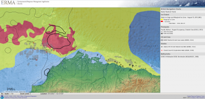
The Arctic Environmental Response Management Application (ERMA®) is a web-based Geographic Information System (GIS) tool that assists emergency responders and environmental resource managers in dealing with incidents that may adversely impact the arctic environment. Arctic ERMA integrates various real-time and static datasets into a single interactive map to provide a visualization of the situation and improve communication and coordination among responders and stakeholders.

The Arctic ERMA was officially launched in July 2012 and is one of eight regional ERMA projects in the U.S. Arctic ERMA was designed as a tool for the Arctic's distinctive conditions, considering variables such as the extent and concentration of sea ice, locations of ports and pipelines, and vulnerable environmental resources.
The launch of Arctic ERMA is part of ongoing efforts by the Interagency Working Group on Coordination of Domestic Energy Development and Permitting in Alaska, which President Obama established in July 2011. This working group aims to coordinate the federal agencies responsible for overseeing the safe and responsible development of onshore and offshore energy in Alaska.
Partners
Arctic ERMA is administered and funded primarily by the National Oceanic and Atmospheric Administration (NOAA) Office of Response and Restoration (OR&R), but many organizations were integral in the development of the Arctic ERMA and continue to contribute to its operation:
University of New Hampshire (UNH) Coastal Response Research Center has been a co-developer and inventor of ERMA. Currently, UNH hosts ERMA and continues to be a partner in continued development. The UNH Coastal Response Research Center also hosts stakeholder workshops in arctic communities in order to have a direct conversation with potentially affected communities, and engages in other stakeholder input activities.
Bureau of Safety and Environmental Enforcement contributed funding to complete the website and to develop an ERMA prototype that will function as a stand-alone system without Internet connectivity. This prototype is now in its final stages and will be tested this summer.
University of Alaska Geographic Information Network of Alaska (GINA) serves as a portal and repository of data and contributes imagery for the state of Alaska.
Alaska Ocean Observing System (AOOS) also serves as a portal and repository for data. Types of data from AOOS include the shorebird atlas and salmon streams.
Alaska ShoreZone Program shares data on coastal mapping and imagery of Alaska.
Oil Spill Recovery Institute (OSRI) provided initial funding for Arctic ERMA.
Inuvialuit Settlement Region Joint Secretariat in Canada has provided in-kind funding as well as funding for a workshop as part of the effort with the Arctic Council's Emergency Prevention, Preparedness and Response (EPPR) working group.
Datasets and Applications
Presently, Arctic ERMA is comprised of over 500 data layers. Examples of available datasets include weather and oceanographic information, ice extent and concentration, nautical charts, ship locations, locations of infrastructure and equipment, environmental sensitivity data, habitat locations, bathymetry, oil infrastructure, critical areas for marine mammals/birds, and satellite information.
Arctic ERMA was already in use before its official launch. In 2010, ERMA was used to monitor and prepare for a spill from the M/V Golden Seas near the Aleutian Islands. In January 2012, it was used to monitor and provide information to the State of Alaska for the U.S. Coast Guard Healy and Russian tanker Renda's fueling operation to Nome.
Since its official launch, it has been used in a few arctic exercises including an industry-sponsored training simulation of an oil spill in the Chukchi Sea in the summer of 2012. Arctic ERMA was also used to monitor the drill rig Kulluk for several days following 31 December 2012 when it ran aground near Kodiak Island. Over the past year, ERMA has been used to show where potential marine debris from the Japan tsunami has impacted Alaskan shores.
Future Plans
Future plans for Arctic ERMA consist of adding data (including local knowledge), keeping all data layers current, and continuing to ensure all metadata are compliant for public release of datasets. There are efforts to move the website into a government domain on cloud-computing resources. Also, this summer the stand-alone ERMA prototype will be completed with the capability of re-syncing once Internet access is secured at a field site.
For further information, see the Arctic ERMA website or contact Amy Merten, Chief, Spatial Data Branch, Office of Response and Restoration (Amy.Merten [at] noaa.gov).
Many thanks to Amy Merten for her contributions to this article.
