Assessment of Current Ice Conditions Relevant to Distribution and Access of Walrus
Click the name of each community below to view more frequently updated and detailed information from the National Weather Service.
Synopsis - High pressure will persist over the Chukchi and Beaufort seas while several low-pressure systems traverse into the Gulf of Alaska, leaving weak low pressure in the eastern Bering Sea. A stronger low and front move into the eastern Bering Sea late in the weekend.
Near St. Lawrence Island
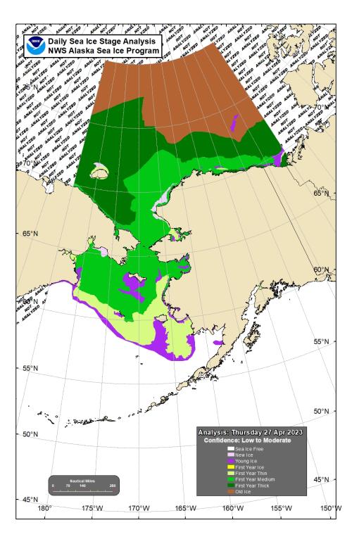
Shorefast ice remains along the northern side of the island. Shorefast extends out up to 10 miles (16 km) from the coastline between Gambell and Eewak Point and extends out 2 to 10 miles (3 to 16 km) offshore from east of Savoonga through Camp Kulowiye. Compacted against the shorefast is close to very close young pack ice with intermingled medium to vast floes of older first-year medium ice. On the southern side of the island, shorefast remains within the bays. The largest shorefast extent is in Oomeyaluk Bay, out up to 7 miles (11 km) from the coast. A large area of open water exists on the southern side of the island and extends outward from the shorefast ice up to 65 miles (105 km). An area of very open pack ice is located 12 miles northwest of Gambell and extends north and westward.
Nome
Shorefast ice extends up to 2 miles (3 km) offshore along the Nome coast, with the exception of up to 7 miles (11 km) offshore near Sledge Island. A large area of open water exists off the shorefast ice from Nome up to Wales. This region of ice-free water extends southward out up to 5 miles (8 km) from the shorefast ice near Nome and extends southwestward out up to 20 miles (32 km) from the shorefast ice near Sledge Island. Southward of there, consolidated ice consisting of vast to giant floes extends 65 miles (105 km) south of Nome.
Nome port entrance webcam (via AOOS webpage): https://bering-sea.portal.aoos.org/?ls=79875242-e362-65cb-914e-fed20ff9…
Brevig Mission/Port Clarence Area
The outlook for this area has not yet begun for the season.
Wales to Shishmaref
The outlook for this area has not yet begun for the season.
Diomede
The outlook for this area has not yet begun for the season.
Forecast Discussion
Ice Forecast
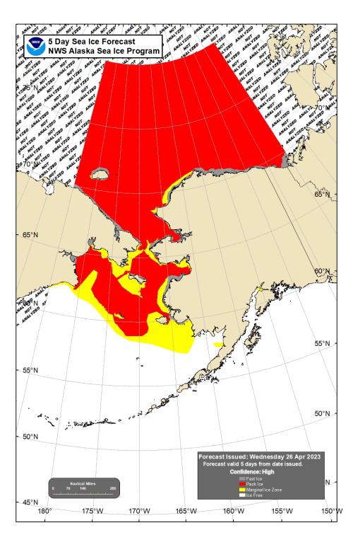
For St. Lawrence Island, the polynya on the south side of the island will continue to expand to the south through the weekend as northerly winds persist. Expect ice to compact against the northern coastline. Air temperatures will moderate, which may decrease ice thickness with additional melting from the late-April sunshine.
For the Nome area coastline, sea ice will move predominately with tides and currents through Saturday. On Sunday, there is a better chance sea ice will move southward with stronger northerly winds which will encourage the polynya to grow south of the shorefast ice. Some of the less stable portions of shorefast ice along the coast from Sledge Island to Norton Bay may break off during these northerly winds.
Wind Synopsis
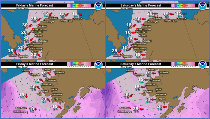
Winds through Saturday, 29 April will follow a diurnal trend of north-northeast winds 20–25 knots (23–29 mph) during the day with gusts to 30 knots (35 mph), decreasing to 9–14 knots (10–16 mph) overnight. Winds will then shift north-northeast 25–30 knots (29–35 mph) with gusts to 35–40 knots (40–46 mph) Sunday afternoon 30 April through early Tuesday, 2 May. Winds will slowly decrease on Tuesday and become northerly 8–13 knots (9–15 mph) with gusts to 20–25 knots (29–35 mph) through the remainder of the period (5 May).
Temperature Trend
For St. Lawrence Island, high temperatures will peak in the upper 20s through Sunday, 30 April, then stabilize in the mid 20s next Monday, 1 May through Friday, 5 May. Low temperatures for St. Lawrence Island will remain in the upper teens to lower 20s throughout the period.
For Nome, temperatures over the weekend will hover around the mid 30s before dipping into the lower 30s by Tuesday, 2 May. Low temperatures for Nome will stay in the lower 20s through Sunday, 30 April, then shift to the mid- to upper-teens through Friday, 5 May.
Daily Weather, Wind, and Temperature Updates
The National Weather Service provides twice-daily, text only updates on the weather, wind, and temperature conditions in specific geographical zones. An interactive weather map for access to other Alaskan zones can be found here: http://weather.gov/anchorage/ice
Higher resolution satellite images and wind maps (wind updated daily) can be viewed here: http://www.weather.gov/afg/SIWO_overview
The Alaska Ocean Observing System shares a variety of weather and sea ice related resources in their Bering Sea Portal at https://bering-sea.portal.aoos.org/.
Marine forecast for the West Coast and Arctic Coast
Remote Sensing Images
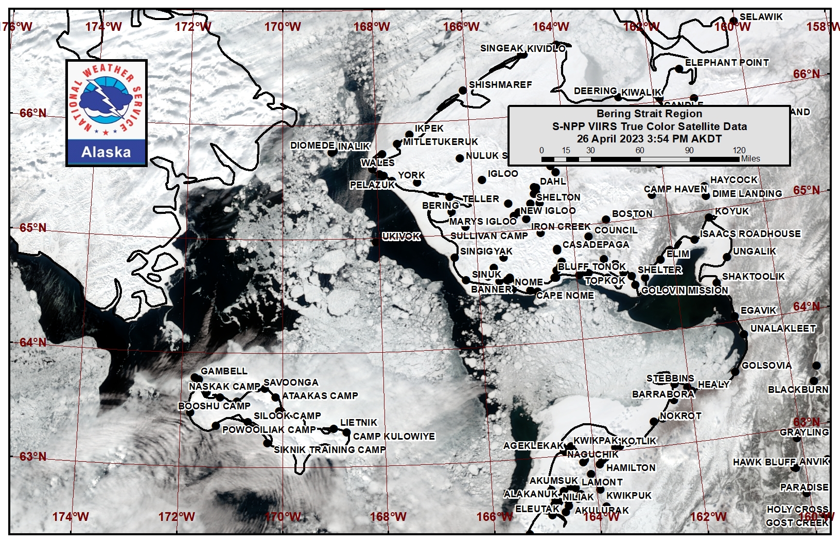
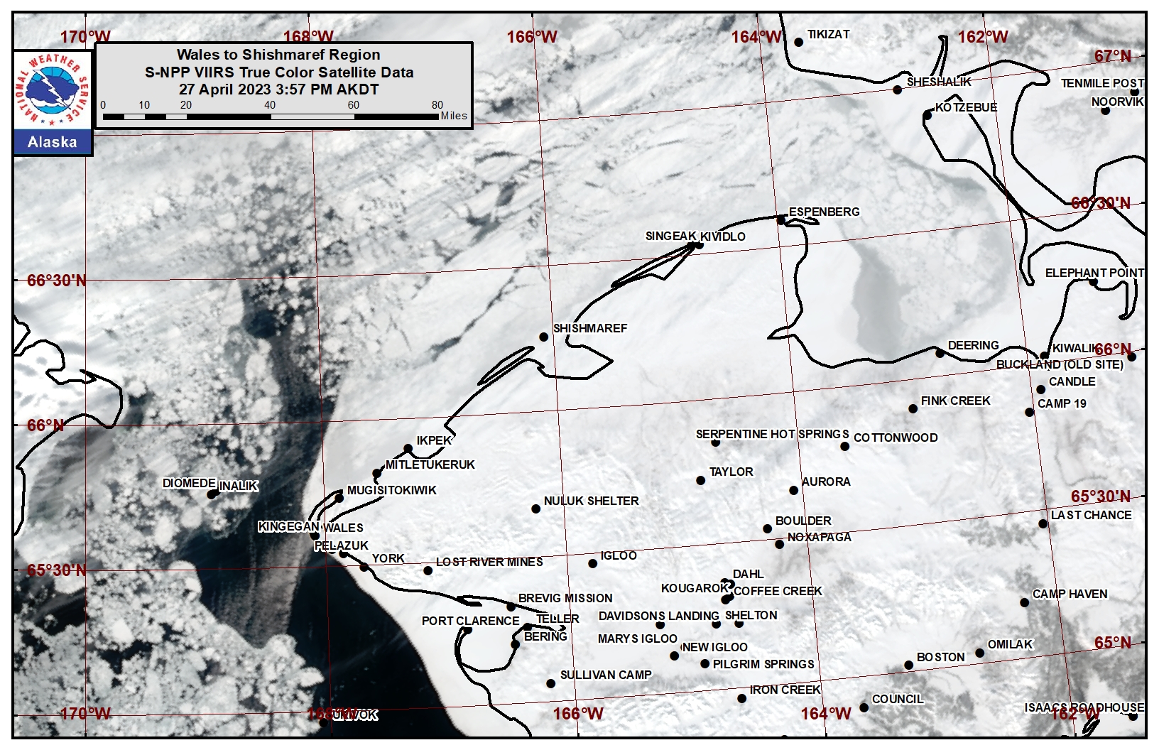
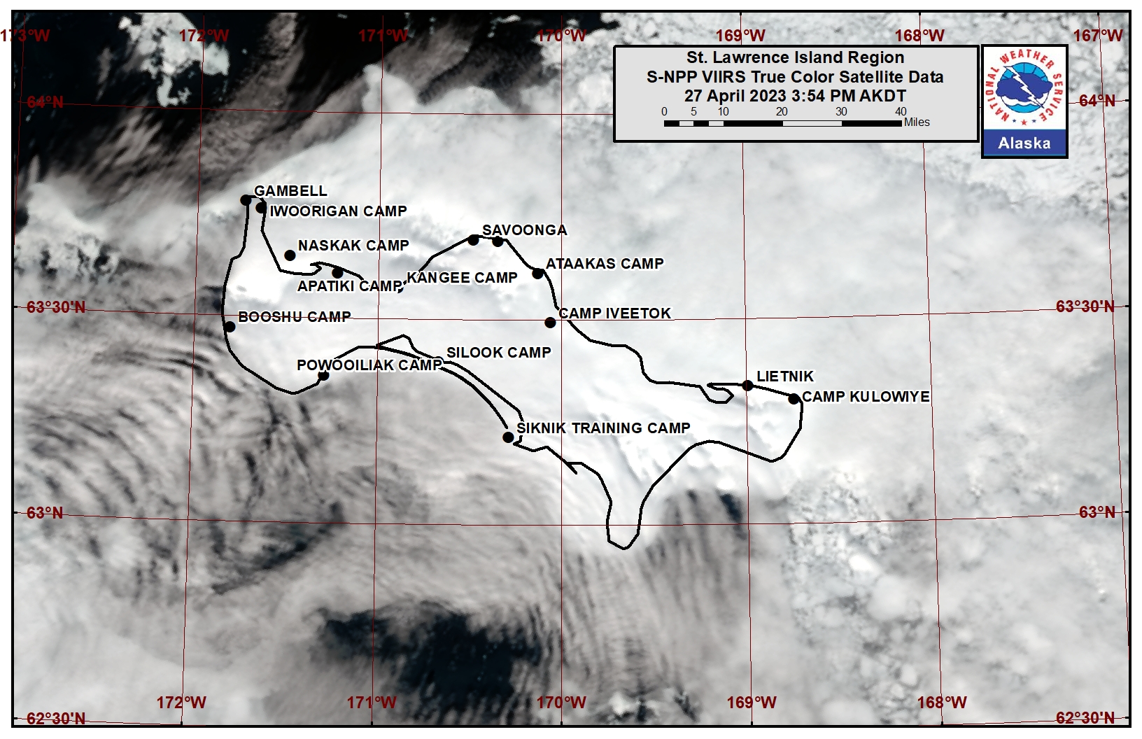
Observations and Comments
Observations of Sea Ice Development
Observations from Wales
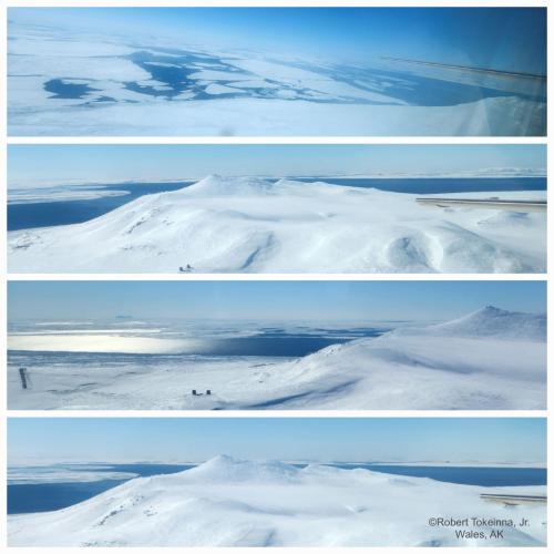
Monday, 24 April 2023 – Robert Tokeinna, Jr.
Sea ice around Cape Prince of Wales mountain.
Observations from Shishmaref
Thursday, 27 April 2023 – Curtis Nayokpuk
Warm temps and calm sunny days. Hunters digging out boats in prep for season. Sure sign of spring seagulls sighted flying by.
Observations from Savoonga
Friday, 28 April 2023 – Aqef Waghiyi
Little breezy today from the north.
From the Kestrel weather station at 14:45 AKT:
Altitude 136
Wind at 14:48 NNE 6.7 mph
Wind at 14:50 ENE 7mph, crosswind 4.4 mph
Temperature 23 deg F
Humidity 100%
Pressure 1008 hPa
Windchill 14.4 deg
Kind of wet blowing snow. Can’t see too far, maybe mile and a half visibility. About two weeks ago snowbirds got in and this week there’s a whole lot more now, seagulls, pintail. Nobody seen geese yet. Nobody spotted sandhill cranes either. Once the sandhill cranes get in the gray whales will be getting in too so it will be harder for us to spot bowhead. No open water and it’s kinda breezy for past few days. No walrus this week.
Observations from Gambell
Saturday, 29 April 2023 – Clarence Irrigoo, Jr.
We have high wind for a week. Last two days we have high surf. Only boating we have was on 22 Apr we see walrus in water and this bearded seal got on the ice. Still high wind and blizzard.
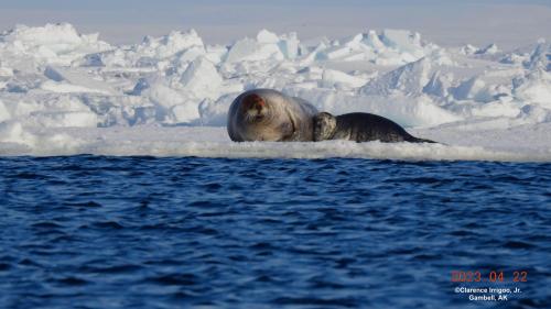
Having milk for ten minutes and burp after.
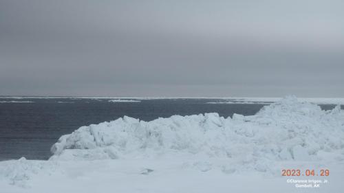
Additional Comments Provided by Local Experts and Other Contributors
Shared by the Alaska Ocean Observing System (AOOS) for 26 April – 4 May 2023
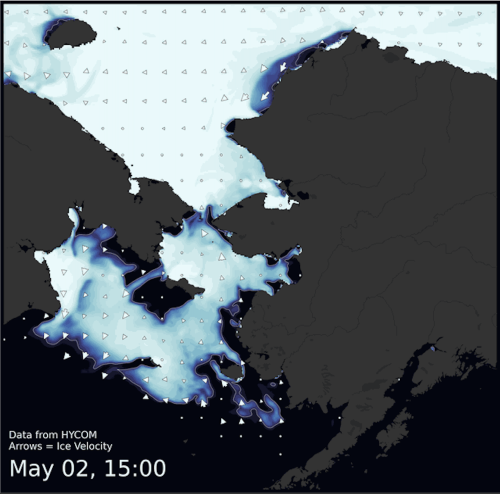
Visit the SIWO Facebook page @seaiceforwalrus to view this animation showing the predicted movement of ice predicted by the HYbrid Coordinate Ocean Model (HYCOM). Snapshots from the forecast show ice coverage from 0% (black) to 100% (white) and arrows show the relative speed and direction of the ice. A light boundary is drawn at 15% predicted ice cover to highlight the ice edge, but ice may be predicted to extend beyond it. Some bays, lagoons, and areas very close to shore are not covered by the model. (Image produced by the Alaska Ocean Observing System / Axiom Data Science).
